BIRMINGHAM, Ala.— Gary Bostany said it was like lava flowing down from above.
In 2023, slow and steady, the rocky mud of Red Mountain came down the slope a little at a time. The sediment began to take over parking spaces in the apartment complex where he lives and works.
Eventually, the material crept toward his building, and Bostany reached out for professional help.
“The engineers called it a slope failure,” Bostany explained. It was a failure he’d done nothing to cause, but the retired artist was stuck with the cost of fixing it. The necessary assessment and dirt removal cost thousands, Bostany said. “They said it was caused by an accumulation of water built up on the mountain over the decades. It’s just part of being in a landslide zone.”
Now, Bostany is one of many Alabamians urging public officials to act in ways that mitigate risks of landslides, particularly as climate change makes extreme rain events more frequent. He is one of thousands of Birmingham residents who live in a landslide risk zone that spans much of the southern-central part of the city, according to municipal planning documents.
Bostany is a member of one of two Birmingham neighborhood associations that have passed resolutions urging the city to reduce landslide risks in the area by dedicating two properties along the landslide risk zone as part of Vulcan Trail, a local park, preventing development or other land use that could increase the risk of costly slope failures aside Red Mountain.
One of the properties, a Birmingham city councilor said, had been approved as a park decades ago, but the formal dedication eventually fell through the cracks. The other property, located nearby along the slope of Red Mountain, is owned by the Birmingham Land Bank Authority, a government-funded entity that stewards tax-delinquent and blighted properties.
A spokesperson for the city said the resolutions would be reviewed and evaluated to “determine any next steps or recommendations from the appropriate departments and subject matter experts.”
Ben Leshchinsky is a civil engineer and professor at Oregon State University’s College of Forestry. An expert on slope failures, Leshchinsky said that both climate change and the limited extent to which we’ve adapted our infrastructure to more extreme weather conditions could increase the risks of landslides. Those increased risks, he said, are something both individuals and policymakers should be considering moving forward.
“Our infrastructure is not necessarily evolving with climate change, but our landscape will evolve with these stronger climatic forces,” he said.
Alabama, like much of the country, has a long history of landslides.
Perhaps the largest in modern history, state geologists have suggested, occurred in 1886 in Cherokee County, when a one-mile portion of a mountain broke off, sliding hundreds of feet and damming the nearby Chattooga River.
There are many different types of geological events referred to as landslides, which are generally defined as any movement of slope-forming soil, rock or vegetation under the influence of gravity, according to the Geological Survey of Alabama. The most common types, according to the state office, are creep, slides and rockfalls.
Creep is a slow downward movement of soil or rocks on slopes. Slides are movements of soil or rock along a rupture and rockfalls are quick movements of rock that fall, bounce or roll downhill.
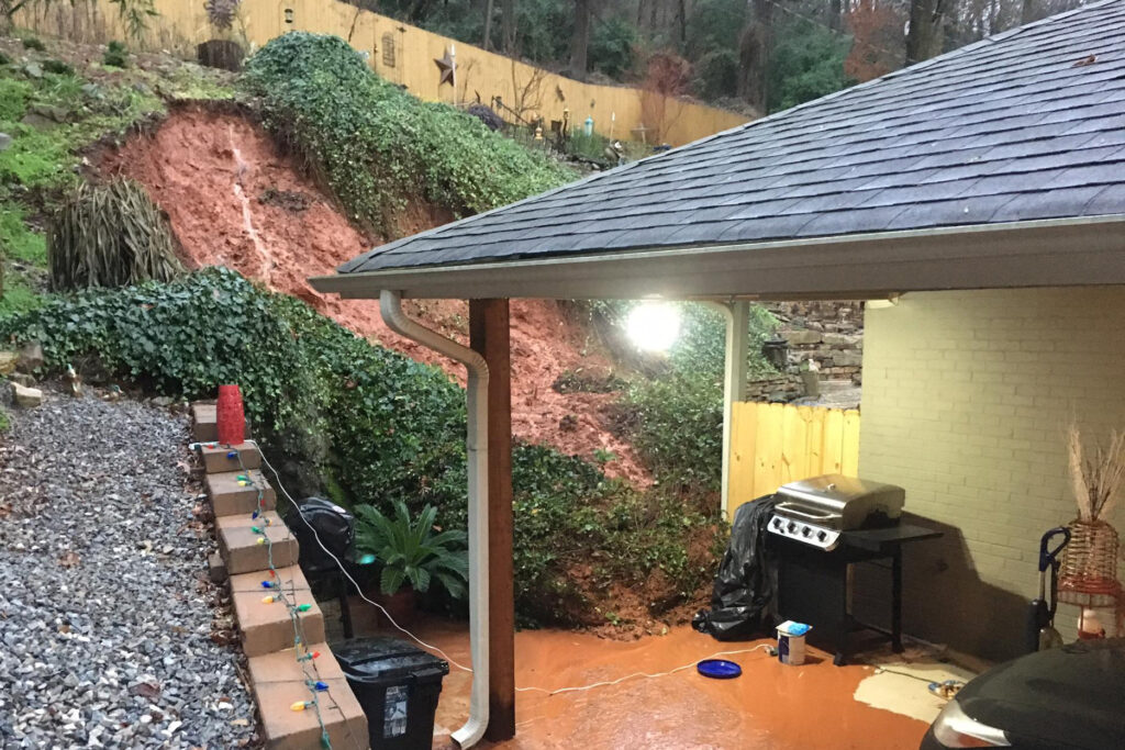
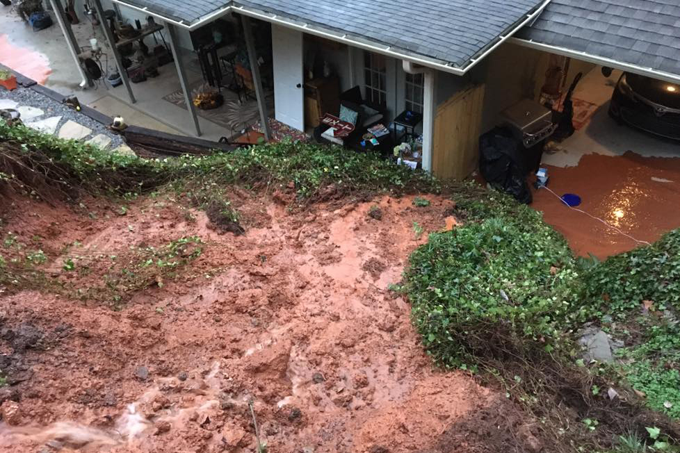
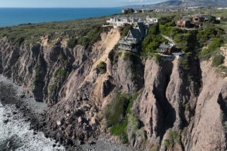
A slope failure near Red Mountain leads to mud and debris breaching a Birmingham home in 2018. Credit: Courtesy photo
Landslides happen frequently across the U.S., leading to billions of dollars in losses each year, according to government figures, and causing an estimated 25 to 50 deaths per year.
But because landslides often happen in combination with other events, like severe weather, their frequency and that of related injuries and deaths may be underestimated, according to Leshchinsky.
“We don’t have great statistics on casualties, but the most common impact of landslides is often property damage or damage to infrastructure,” he said.
Governments at all levels—local, state and federal—are impacted by landslides. A project conducted by Auburn University’s College of Engineering and submitted to the Alabama Department of Transportation in 2019 led to the creation of a database of over 250 landslides along state highways during a three-decade period.
Aside from safety risks, landslides along roadways can lead to large direct repair costs and indirect costs such as “traffic disruption, driver inconvenience, commercial losses, road closure, and secondary maintenance,” according to the report.
In 2022, the City of Birmingham closed Woodcrest Road on Red Mountain due to “concerns over roadway settlement along a steep slope.” Now, nearly two years later, a city spokesperson said that while a geotechnical assessment has been completed on the road, there is currently no timeline for its reopening.
“Minor stabilization work will be performed along the edge of the roadway along with continued monitoring,” the spokesperson said. “Upon the completion of that work, the road can be reopened.”
Bostany is worried that if government officials don’t act to mitigate the risks of landslides, both property and people could be at risk.
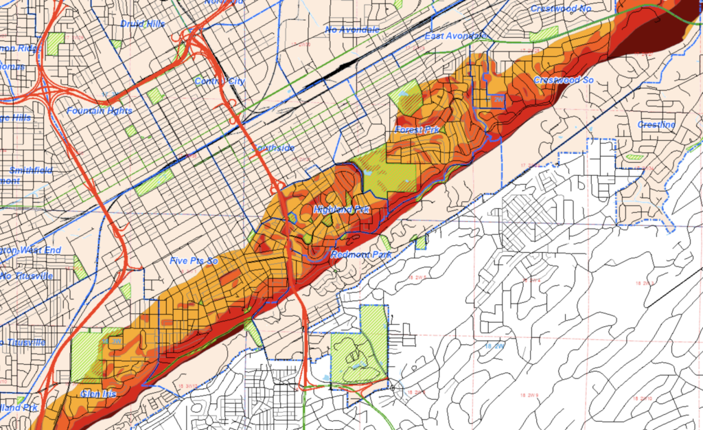
The landslide risk zone where he lives stretches around seven miles across Birmingham, from Glen Iris near I-65 in the west to Eastwood near I-20 in the east, reaching many blocks northwest from the base of Red Mountain, reaching as far as Avondale Park. Within the zone are many areas of high susceptibility to landslides, including Eastwood.
There, in 1988, an apartment complex collapsed on Red Mountain during the construction of the Crestwood Festival Center, a shopping area, at its base. Several people had to force their way out of the collapsed buildings, according to press reports. One woman was physically injured.
“I looked outside and saw the trench opening up in the ground, like an earthquake,” a woman who’d escaped the collapsed building told the Birmingham Post-Herald. She’d kicked out a glass door and crawled to safety, the paper reported.
A retrospective report on the landslide blamed poor planning and inadequate design for the collapse, which in addition to the trauma of those involved caused more than $26 million in property damage, adjusted for inflation. The Birmingham City Council had approved the rezoning necessary for the shopping center—over residents’ objections, according to press reports from the time.
Construction and other development-related missteps are unforced errors, in Bostany’s view. It’s why he’s opposed development on the mountainside as far back as the 1970s, years before the Crestwood Festival Center collapse. Back then, residents had filed suit against an unrelated residential developer whose construction they feared would cause landslides. Valerie Abbott, now Birmingham’s longest-serving city councilor, was already active in politics at the time.
“The people who lived there were petrified that the mountain would slide down on their houses,” she said.
As a result of the suit, Abbott said, local homeowners were able to force the city to buy the property near Bostany’s house from the developer to prevent future landslide risk. She said both she and Bostany were at a subsequent city council meeting when members voted to dedicate the property as part of Vulcan Trail Park.
Decades passed, and the city’s priorities shifted. In 2017, city officials put that same property near Bostany’s house up for sale to the highest bidder, having somehow failed to turn the tract into parkland as the city council had, by vote, directed it to do back in 1988. A request for proposal issued by the city instructed interested developers to develop proposals that “maximize the market value of the property” and “maximize the overall purchase price of the property.”
Abbott, the city councilor who’d advocated for making the property part of the Vulcan Trail in the 1970s, said she’d “stumbled on the fact that it was for sale by the city,” providing another potentially risky opportunity for a developer to mismanage a property inside a landslide zone.
Bostany said the property’s parks designation had somehow fallen through the cracks.
“A lot falls through the cracks around here,” he said.
But the property never sold, and now he and other residents are asking the city to get the job done once again.
The resolution passed by the Glen Iris and Five Points South Neighborhood Associations calls for the city to dedicate the property—again—as part of Vulcan Trail.
Leshchinsky said there is some logic to leaving land undisturbed to reduce the risk of landslides. Landslides are a natural phenomenon that would happen regardless of development, he explained, but that doesn’t mean that human activities can’t contribute to, or even cause, landslides.
“When we build things, what we can do is accelerate the frequency with which landslides happen, especially if we don’t pay attention to developing things with high engineering standards,” he said.
Rick Journey, a spokesperson for the City of Birmingham, said in response to questions from Inside Climate News that the city mitigates the risk of landslides through the requirement of pre- and post-construction engineering affidavits “to ensure acceptable engineering practices are implemented for surface ground slope and subsurface soil conditions present at a particular site.”
Birmingham’s landslide risk map was created in 1994, Journey said, and the city “does not have a record of any historical slope failures within our mapping environment.” The map simply guides planning and construction design, he said. Despite the plan’s age, “the city is not aware of any changing conditions warranting a need to update these maps,” according to Journey.
Leshchinsky said global warming is changing the ways scientists think about landslide risk.
“One thing that’s expected of climate change is more extremes, rainfall events included,” he said. “And if you have more intense rainfall events, and maybe more frequent intense rainfall events, what you’ll have is more landslides.”
Research from around the globe has found that climate change-related weather patterns have increased landslide risk. Alabama’s highway landslide data, too, confirms Leshchinsky’s suggestion: more rain means more landslides. And more rain is coming.
“Increases in extreme precipitation are projected for Alabama because it is virtually certain that atmospheric water vapor will increase in a warmer world,” according to NOAA Centers for Environmental Information.
Robert Emberson works as a research scientist studying landslides for NASA’s Goddard Space Flight Center.
He said that everyone should be aware of the risk of landslides, particularly if you live in an area that is prone to slope failures.
“People living on or downslope from hillslopes that are susceptible to landslides should be aware of the potential for landslide hazards. Buildings constructed on slopes that were at one point stable can become more exposed over time as landslides eat into the hillslope, ‘undercutting’ existing construction,” he said.
Climate change will only make those risks more unpredictable, Emberson said, and could be compounded by changes in population and in where people live.
“The EPA notes that higher temperatures could well lead to higher rainfall intensity during tropical storms and hurricanes, which could lead to greater incidence of landslides triggered by rainfall,” he said.
This story is funded by readers like you.
Our nonprofit newsroom provides award-winning climate coverage free of charge and advertising. We rely on donations from readers like you to keep going. Please donate now to support our work.
Donate NowCouncilor Abbott said she’s well aware that a changing climate will mean more frequent, more complex challenges for Birmingham, including mitigating landslide risks.
But these risks aren’t foreign, Abbott said. She recalled attending a celebration for a condo development on Red Mountain at some point in her city council tenure.
“We went up to the club and had wine and cheese, and they announced their project and were all excited,” she explained. “Like two months later, the whole mountain slid down and their property ended up on Eighth Avenue in a big pile.”
Whether that incident is in the city’s “mapping environment,” Abbott doesn’t know, but she knows that city leaders should be working to lessen the risks that climate change will inevitably compound. Having the city acquire and protect property inside the landslide zone—property meant to be part of Vulcan Trail decades ago—could be the start of that important work, she said.
“A ball was dropped a long time ago,” Abbott said. “We should pick it up.”

Lee Hedgepeth
Reporter, Alabama
Lee Hedgepeth is Inside Climate News’ Alabama reporter. Raised in Grand Bay, Alabama, a small town on the Gulf Coast, Lee holds master’s degrees in community journalism and political development from the University of Alabama and Tulane University. Lee is the founder of Tread, a newsletter of Southern journalism, and has also worked for news outlets across Alabama, including CBS 42, Alabama Political Reporter and the Anniston Star. His reporting has focused on issues impacting members of marginalized groups, including homelessness, poverty, and the death penalty. His award-winning journalism has appeared in publications across the country and has been cited by the New York Times, the Wall Street Journal and the Washington Post, among others.